~ Central America ~ South America ~ South Pacific ~ Islands ~ Caribbean ~
~ North America ~ Family ~ T. F. Estates ~ Dreams ~ Contact ~ Home ~
Panama's
NATIONAL PARKS
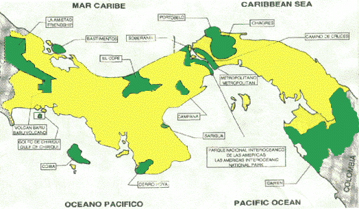
The National Institute of Natural Renewable Resources (INRENARE) through the Directorate of Protected Areas and Wildlife has established 14 National Parks with a total area of 1,391,833 hectares representing approximately 22% of the surface area of the country.
In alphabetical order, Panama's National Parks are:
1. Altos de Campana National Park
2. Amistad National Park
3. Bastimentos Island National Marine Park
4. Cerro Hoya National Park
5. Coiba Island National Park
6. Chagres National Park
7. Darien National Park
8. El Cope National Park
9. Las Cruces Trail National Park
10. Metropolitan Nature Park
11. Portobelo National Park
12. Sarigua National Park
13. Soberania National Park
14. Volcan Baru National Park
Brief Description of these Parks
1. Altos de Campana National Park.
Located in the Province of Panama about 50 kilometers (one hour drive) west from Panama City. Campana is Panama's first National Park, being legally established in 1967(?). The Park protects 4,816 hectares of great biological diversity. Panama's famous "Golden Frogs" can be found here. Cerro Campana straddles two watersheds, the Sajalices River , which flows into the Pacific, and the Chagres River basin, which is the water catchment system for the Panama Canal. The Park protects a significant portion of the Canal operating area. According to scientists at the University of Panama and the Smithsonian Tropical Research Institute the elevation of the basaltic rock that forms the pictoresque cliffs contributes to species richness of both flora and fauna. Students and Faculty from the University of Panama have developed an interpretive nature trail that is both fun and educational. Plants and animals are described in a self-guided tourbook, which is available at the Tupper Center, Smithsonian Tropical Research Institute, Ancon, Republic of Panama.
"Amistad" means FRIENDSHIP and that is an appropriate name for this park because it is an international park shared by Costa Rica and Panama. This park is located within two Panamanian provinces, Chiriqui and Bocas del Toro. It is located in the western part of Panama, almost 500 kilometers from Panama City. The park entrance at Cerro Punta is about one hour north of the city of David, which has an airport and car rental facilities. The park is mostly mountanous, and because of the elevation changes, a great diversity of life zones is found there. With an area of some 207,000 hectares, it is Panama's second largest park. The Darien is the largest. Amistad National Park protects the hydrographic basins of the rivers Teribe and Changuinola. Please refer to the accompanying map of Panama.
Snorkelers and scuba divers who have been to this park claim it is one of the best dive sites in all of Panama! Just check out the Balboa Dive Club calendar for 1996. Contact DoDDS teacher Anita Seifert, for more information. Crystal waters and unspoiled coral reefs attract more than 200 species of marine fish. Turtle nesting sites and visits by manatees enhance the value of the park. So, how do you get there? Distance from Panama City is an hour by plane. By car you drive to Chiriqui, you skirt the Fortuna Hydroelectric Project [also worth a visit] continue on to Chiriqui Grande. Here you take a ferry to Colon Island then you take a boat to the marine park. By land, this is a long day's trip (14 hours). Hotels are available at Colon Island, Almirante and Changuinola. The Biological Honor Society of Balboa High School recently visited this park. Contact DoDDS teacher David Seitz by cc:Mail for more information.
Located in the southwest corner of the Azuero Peninsula, this 32,557 hectare park protects wild life in one of the most agriculturally devastated regions of Panama, Veraguas and Los Santos. Human population pressure, over-grazing, and seasonal burning have all contributed to the ecological decline of the central provinces. More than 30 species of endemic plants have been recorded here. Las Tablas, Panama's Carnival Capital, is a reasonable distance away. So, you might want to take a break from carnival festivities and enjoy the peace and solitude of this park!
Coiba is the largest coastal island [270,125 hectares] within Panamanian waters. It used to be a maximum security prison with a bad reputation. It is the site of the largest expanse of lowland tropical forest in the entire Republic. Scarlet macaws have been reported breeding on the Island. There is a road [unpaved] system permitting access to major parts of the island, but, at this writing, there is no public hotel. People have boated to the park using their boat as their accomodations. Coiba has the potential to be like the island in "Jurassic Park" although without T. rex.
According to the Balboa Dive Club, "[w]ithout a doubt, some of the most spectacular diving in Panama is found around the large Pacific island of Coiba. . . ." You should also consider Jicaron and Jicarita Islands, located adjacent to Coiba Island. Trips there must be arranged in advance with INRENARE. See the information at the end of this document.
The main function of this park is the conservation of the hydrographic basin of the Panama Canal. Approximately 80% of the water necessary for the operation of the canal and all the drinking water for Panama City come from this watershed. The park encompases approximately 129,000 hectares in two provinces, Panama and Colon. Lago Alajuela [a.k.a. "Madden Lake"] and its trubutaries are the major attraction of this park. White water rafting is becoming popular within the park. Several commercial tourist agencies organize day tours to the park and they are worth checking out! Because of its proximity to both major cities, Panama and Colon, day trips are feasable. A portion of the Las Cruces Trail traverses the park.
This is the largest of all the Panamanian National Parks with an area of 579,000 hectares. In 1981 the Darien National Park was categorized as a World-Wide Patrimony Site and in 1983 it was designated as a Biosphere Reserve. These legal designations help establish the level of protection necessary to preserve the park for future generations. Three Amerindian ethnic groups live within the park: Embera, Waunana and Kuna. Part of the park is mountanous. Cerro Pirre, Cerro Nique, and Cerro Tacarcuna are all located within the park boundaries. Macaws, parrots, pecaries, and tapirs live on the slopes of these tropical forests. The park is also home for the harpy eagle, the national bird of Panama, which is considered by some to be the most powerful bird of prey in the world. The Darien National Park has other value as well. It is a natural barrier to dissemination of infectious diseases such as aftosa or "hoof and mouth disease." Primarily for this reason no road has ever been constructed through the park thus giving rise to the nickname "the Darien Gap." Accomodations are available at Rancho Frio, but arrangements must be made in advance through INRENARE. See the end of this document.
Panama's Populist leader Major General Omar Torrijos Herrera made this place famous. Legendary for his penchant for flying to remote places in bad weather, Panama's signatory to the Torrijos-Carter Treaty contributed to the establishment of this protected area by fatally crashing here during a thunderstorm, July 1983. Before his death, the General had "adopted" the pueblo of El Cope, making frequent visits there and contributing to the social and economic development of the community. To his eternal credit Omar Torrijos clearly communicated to the public that he cared for people. El Cope is his legacy.
The park encompases about 6,000 hectares and protects the hydrographic basins of the rivers Bermejo and Marta of the Pacific slope, and the rivers Blanco, Guabal and Lajas of the Caribbean slope. El Cope is a cloud forest reserve of rubber and medlar (?) trees typical of the mountanous ridge forming the backbone of the Isthmus. Zamia, a type of cycad, [that is, a non-flowering, naked seed, vascular plant or gymnosperm] is endemic to this region. Gnetum, another unusual gymnosperm, is also found at El Cope.
The Gold of the Incan Empire crossed Panama on its way to Spain along the cobblestones of the Las Cruces Trail. Along that forested path you can still hear sounds that were heard by Balboa and Morgan. You can see the forested Panama of the Conquistadores five hundred years ago. Five hundred years from now, will the same be true? Or, will a multilane highway cross the Isthmus at this point? National Parks preserve a heritage that, once lost, can never be recovered.
Las Cruces Trail National Park is a corridor of 4,000 hectares that links the forested zones between the Metropolitan Nature Park and the Soberania National Park. A great variety of flora and fauna is found between the two major cities of the Republic. The Panamanian tamarin, two-toed and three-toed sloths, and howler monkeys are among the attractions of this endangered zone. The advantage of this area is the very thing that threatens it the most: proximity to urban areas.
Fifteen minutes from dowtown Panama is the 265 hectare Metropolitan Nature Park. The forest green of the park can be seen from the windows of the city highrise apartments. This is one of the few urban parks in the world. It is unique in all of Latin America. The park is an excellent opportunity for environmental education, having meeting rooms [the Panama Audubon Society meets here], a small museum, a library, and a shop that sells conservation items. The interpretive trail is enjoyed by visitors and school groups. The view from the top of Cerro Mono Titi is spectacular offering a panoramic view of the city, the Port of Balboa, and the adjacent Las Cruces Trail National Park. Birding is especially good here. The orchid garden is also worth a visit!
Unfortunately, the legal authority of the Metropolitan Nature Park has been compromized by a new superhighway that cuts through the park.
Located on the Caribbean in the Province of Colon, this 34,846 hectare park protects coral reef communities and coastal forest. In colonial times it was the site of storehouses for the gold and silver of South America. It was here that Spanish galleons loaded on treasure for the voyage back to Europe. The pirates of the Caribbean all had their eyes on the treasures of Portobelo. A few of them got their hands on it as well! Definitly worth visiting are the military fortresses that bear testimony to the importance of this site in Colonial times.
If you scuba dive be sure to check out Drake's Island, Salmedena Reef, the Three Sisters, and Playa Blanca. Not to be missed!
This is Panama's "desert." Though not a desert in strict ecological terms [Sarigua receives more than a meter of rain each year], the salt pans, the wind-blown sand, and cacti all evoke the image of "death valley." In fact, Sarigua is a lesson in the peril of poor land management. Over-grazing, loss of topsoil, and erosion all combine to create 8,000 hectares of devastation. If you want to study the biology of drought-stressed vegetation this is the place! Parkinsonia ("palo verde"), Opuntia ("prickly pear cactus") Sesuvium ("ice plant") Gossypum ("wild cotton") are the obvious vegetation [where there is vegetation]. Bring sunscreen and wear a broad-brimmed hat.
In addition to the ecological considerations, Sarigua is, according to Dr. Richard Cooke of the Smithsonian Tropical Research Institute, the most important Pre-Columbian site in the Republic of Panama. Dating back 11,000 years based on shell mounds and pottery fragments, Sarigua offers an unparalleled archeological opportunity. An on-site museum displays representative artifacts. Contact Dr. Richard Cooke @stri.edu for more information.
While you are at Sarigua, it is worthwhile to make a side trip to Playa Agallito to visit the mangroves. Rhizophora ("red mangrove"), Avicennia ("black mangrove") and Conocarpus ("button mangrove") are the main primary producers here.
Excellent accomodations are available at Hotel Hong Kong in Chitre.
25 kilometers from Panama City, Soberania National Park offers two outstanding features: (1) Pipeline Road and (2) El Charco interpretive trail. Pipeline Road, long known to tropical biologists, is one for the record books. According to the Panama Audubon Society, at this site during December1992/January 1993, 525 species were recorded during the annual Christmas bird count. Pipeline Road is a wonderful hike any time of year, for any reason. Howler monkeys, trogons, toucans, Morpho butterflies are among the regulars here. Bridges over forest streams are wonderful rest stops for a snack or trail lunch. Caution: Don't go "high fives" with the "black palm."
Sendero El Charco [the interpretive trail] is excellent for beginners. It is short (less than 2 kilometers), a closed circuit (you end where you started, only smarter), and you can go swimming. Labelled signs help with identification. Rumor has it that a pamphlet in Spanish and English will be available for those who learn from the written word. This is an excellent field trip for biology classes. You can do it in one hour or so. And you can do it many, many times and it doesn't get boring. Either the membrillo is in fruit or the folofa ants are foraging. Something is always happening!
3,475 meters above sea level, Volcan Baru is the highest point in Panama. The Resplendent Quetzal is a world class find! Endemic species include the Volcano Junco and the Baru Burbit. Endemic oak trees (Quercus baruensis) are a remnant of more extensive forests in the geological past. Hotel accomodations are available in two of the most beautiful towns in the entire country: Boquete and Cerro Punta. A vacation here is heaven on earth. Boquete is also home to an annual Flower Festival that should not be missed.
Main
| General
Information | Getting
There | Social
Customs |
Tours
| Activities
& Interests | Hotels
Important
Dates | Car
Rental | Money
& Banks | Newspapers
| Climate
| Maps